Winter Storms Wreak Havoc Across the United States
A Series of Severe Winter Storms Impact Millions
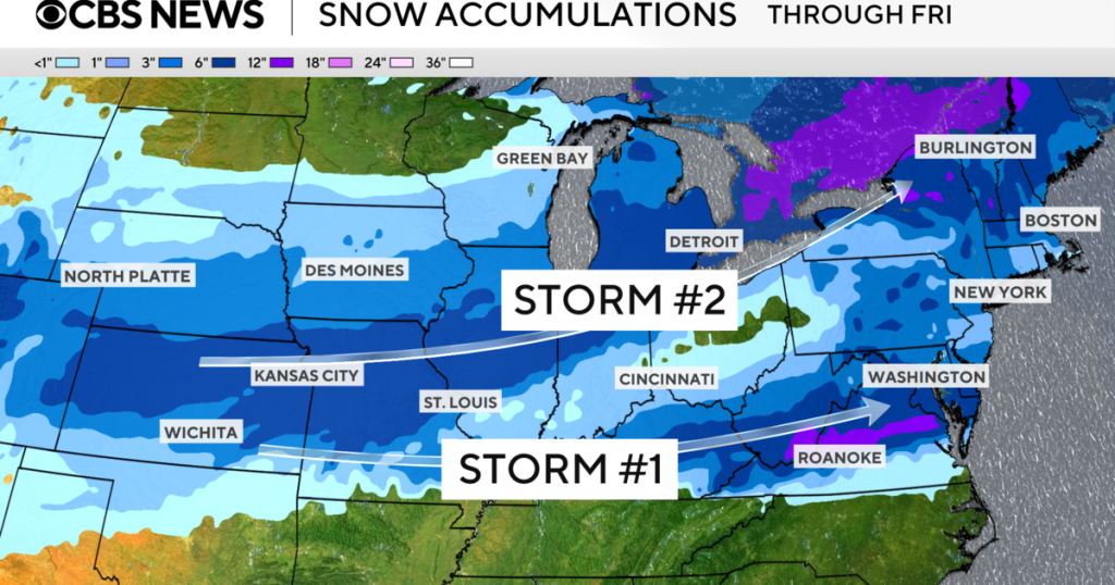
The United States faced a relentless wave of winter storms this week, with over 80 million people from the Midwest to the East Coast under threat of severe weather. The National Weather Service warned of heavy snow and ice, particularly in the Ohio Valley, Mid-Atlantic, and Central Appalachians. By Wednesday, the region could see significant ice accumulation, while the Central Plains braced for heavy snow and ice from another storm system. Forecast maps revealed the pathways of these powerful systems, signaling a week of wintry extremes across multiple regions.
CBS News meteorologist Nikki Nolan highlighted the dual threat of storms, with one system tracking northeast from the Great Plains. This storm was expected to impact the Midwest and Northeast by Wednesday and Thursday, bringing heavy snow, sleet, and ice. Areas along the I-95 corridor, from Richmond to Philadelphia, were warned of snowfall rates reaching up to 1 inch per hour, with totals of 4-8 inches of heavy, wet snow. Isolated power outages and hazardous travel conditions, especially during the Tuesday evening commute, were among the top concerns.
Severe Weather Warnings and PotentialHazards
The northern side of the storms brought snow, sleet, and ice, while the southern side faced potentially severe, heavy rain. Weather warnings remained in place through Thursday for large sections of the eastern U.S., as forecasters predicted the next winter storm could blanket wide areas with up to 10 inches of snow. Additionally, extreme cold warnings and cold weather advisories were issued for parts of the Northern Rockies, Great Lakes, and Central Plains, as an Arctic front drove temperatures 25 to 35 degrees below average.
Local weather services in Chicago and Hastings, Nebraska, urged residents to prepare for 6 to 8 inches of snow, while parts of central Virginia and West Virginia readied for up to half an inch of ice. National forecasters warned of excessive rainfall in the Lower Mississippi and Tennessee Valleys, as well as the Southern Appalachians, raising the risks of flash and river flooding.
Heavy Snow and Freezing Rain CreateTravel Dangers
Forecasters anticipated heavy snow developing Wednesday from the Central Plains to the Great Lakes, with snowfall rates of around 1 inch per hour at times. These areas could see at least 5 inches of accumulation, while eastern Oklahoma and the Ozarks were likely to experience a mix of sleet and freezing rain. Even farther south, where less than an inch of freezing rain was forecast, untreated surfaces could still become hazardous for travel.
Communities Brace for Back-to-BackStorms
Some communities were bracing for one storm system to be quickly followed by another, with the National Weather Service describing the second system as "significant." This storm was expected to bring chilling temperatures, heavy snow, and ice to the Central Appalachians and Central Plains. The overlapping threats of snow, ice, and extreme cold underscored the importance of preparedness, as residents stocked up on supplies and emergency management teams stood ready to respond to power outages and travel disruptions.
A Call to Action for Safety andPreparedness
As the storms moved across the country, authorities and meteorologists emphasized the need for vigilance and caution. With hazardous travel conditions, freezing temperatures, and the potential for flooding, residents were urged to stay informed and take necessary precautions. The combination of severe weather and Arctic cold created a dangerous scenario, but with proper planning and community support, many hoped to weather the storms safely.


